A History of the Lunæs Montes
The arch-colonist Henry Morton Stanley in his
In
Darkest Africa, Vol II (Ch. 29) provides a
good summary of the written history of the quest for
the Rwenzoris. That quest is inextricably
linked with the quest for the source of the Nile.
Some History
 It is
perhaps not surprising that explorers
from as far back as Homer's age (c. 850 BC), whose
knowledge of Africa was
primary through their interaction with Egypt, were
captivated by the quest for the source of the
Nile. It is
perhaps not surprising that explorers
from as far back as Homer's age (c. 850 BC), whose
knowledge of Africa was
primary through their interaction with Egypt, were
captivated by the quest for the source of the
Nile.
The Nile's source however was to prove elusive for
many years to come. A map by Hipparchus (c. 100 BC)
shows the Nile flowing out of three lakes north of the
equator. Another by Ptolemy
(c. 150 AD) follows the same idea, but places the
lakes south of the equator. (It is interesting to note
how so close to the truth the ancients were.)
With succeeding years, more
detail was added to this picture, but it was not until
1862 that the source of the White Nile was
finally fixed on the map by J H Speke. (We don't like to use the word
'discovered' much, since the locals knew for centuries
wherere the source was. It's just the nosy explorers who
didn't!)
As far back as 500 BC,
geographers had come to believe that the Nile flowed
out of "fountains" somewhere in Central
Africa. Ptolemy was the first to postulate that these
were to be found in
the Lunæs Montes ("Mountains of the Mooni"),
somewhere deep inside central Africa. This is
echoed in subsequent Africa maps through the ages.
Of all the explorers who wrote of these mountains,
none seems to have seen them, as is evidenced by the
amount of myth surrounding them. Tales abound of magical
kingdoms, strange beasts, bright shiny objects and great
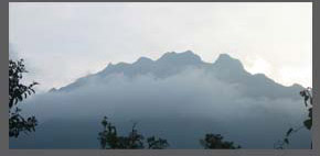
mists. H M Stanley first glimpses them in the 1870s
from a great distance. As is the case today, because
the peaks are usually shrouded in clouds, the
mountains were not easy to see. Stanley provides a
lucid and engaging account
(ch. 30) of his encounter with the Rwenzoris, which he
finally fixes on the map of Africa in
April 1885.
About the Rwenzoris
 The Rwenzoris are a 90-mile long range of block mountains on the
western border of Uganda, somewhat between Lake George
and Lake Albert. They form the western border of the
part of the Great East African Rift Valley that passes
through Uganda.
The Rwenzoris are a 90-mile long range of block mountains on the
western border of Uganda, somewhat between Lake George
and Lake Albert. They form the western border of the
part of the Great East African Rift Valley that passes
through Uganda.
The Rwenzoris consist of a variety of peaks, ravines
and ridges. The three highest mountains in the range
are Mt. Speke, Mt. Stanley and Mt. Baker. The highest
peak of the Rwenzoris is Margherita Peak on Mt. Stanley
(at 5110m above mean sea-level). This is the third
highest peak in Africa, after Kilimanjaro and
Mt. Kenya, but is considered the most arduous climb
in Africa.
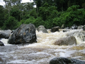
Because they receive a large amount of
rainfall, the mountains are criss-crossed by many
rivers and streams. The vegetation in the Rwenzoris also tends to be
quite thick and prone to gigantism. There is also a
variety of wildlife, including elephants, chimpanzee,
monkeys, leopards and antelope.
|